Файл:Qatar 31 January 2003.jpg

Повна роздільність (1110 × 1375 пікселів, розмір файлу: 656 КБ, MIME-тип: image/jpeg)
| Відомості про цей файл містяться на Вікісховищі — централізованому сховищі вільних файлів мультимедіа для використання у проектах Фонду Вікімедіа. |
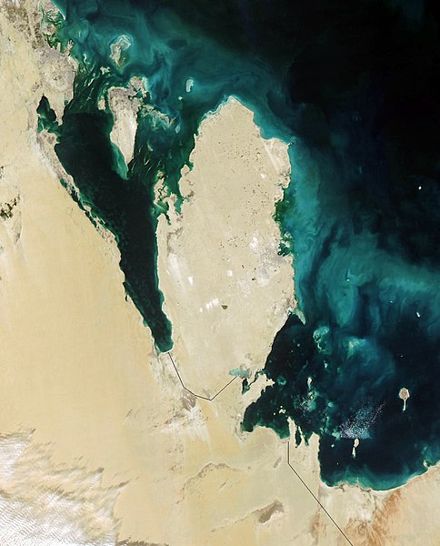
Qatar
This true-color Moderate Resolution Imaging Spectroradiometer (MODIS) image from January 31, 2003, featuresthe Persian Gulf in the Middle East. Seven countries sit on the Gulf(clockwise from top right): Iran, Oman, the United Arab Emirates, SaudiArabia, Qatar, Kuwait, and Iraq. In addition to the tip of the peninsulareaching toward Iran, Oman also stretches to the southeast along the Gulfof Oman (bottom right corner).
The Persian Gulf, officially known as The Gulf, features clouds ofblue and green in its dark waters. These clouds likely indicate a mixtureof sediment and microscopic marine plant life. At the top of The Gulf,where Kuwait, Iraq, and Iran meet, two rivers flow into the Gulf and addtan streaks to the water. These rivers are the Euphrates and the Tigris,the source of the Fertile Crescent valley and between which the ancientMesopotamian civilization flourished.
A number of fires were detected in this scene by MODIS and are markedin red. They are concentrated in southern Iraq and western Iran. The onesin southern Iraq are likely associated with oil wells. Snow can also beseen blanketing the Zagros Mountains of Iran at the upper center of theimage.
http://visibleearth.nasa.gov/view_rec.php?id=4981
| Цей файл перебуває у суспільному надбанні, оскільки він був створений NASA (Національним управлінням з аеронавтики і дослідження космічного простору). Згідно з політикою NASA стосовно авторського права, «матеріали NASA не захищаються авторським правом, якщо не вказано протилежне». (Див. Template:PD-USGov, сторінку політики NASA стосовно авторського права, або політику використання зображень JPL.) | ||
 |
Попередження:
|
.jpg)
Історія файлу
Клацніть на дату/час, щоб переглянути, як тоді виглядав файл.
| Дата/час | Мініатюра | Розмір об'єкта | Користувач | Коментар | |
|---|---|---|---|---|---|
| поточний | 06:39, 26 жовтня 2005 | | 1110 × 1375 (656 КБ) | Brian0918 | Qatar This true-color Moderate Resolution Imaging Spectroradiometer (MODIS) image from January 31, 2003, featuresthe Persian Gulf in the Middle East. Seven countries sit on the Gulf(clockwise from top right): Iran, Oman, the United Arab Emirates, SaudiAr |
Використання файлу
Такі сторінки використовують цей файл:
Глобальне використання файлу
Цей файл використовують такі інші вікі:
- Використання в ar.wikipedia.org
- Використання в az.wikipedia.org
- Використання в bcl.wikipedia.org
- Використання в bn.wikipedia.org
- Використання в ca.wikipedia.org
- Використання в ceb.wikipedia.org
- Використання в de.wikivoyage.org
- Використання в el.wikipedia.org
- Використання в en.wikipedia.org
- Використання в en.wikivoyage.org
- Використання в es.wikipedia.org
- Використання в fi.wikipedia.org
- Використання в fr.wikipedia.org
- Використання в he.wikipedia.org
- Використання в he.wikivoyage.org
- Використання в hr.wikipedia.org
- Використання в it.wikipedia.org
- Використання в it.wikivoyage.org
- Використання в ja.wikipedia.org
- Використання в ko.wikipedia.org
- Використання в mn.wikipedia.org
- Використання в nl.wikipedia.org
- Використання в nn.wikipedia.org
- Використання в pl.wikipedia.org
- Використання в pt.wikipedia.org
- Використання в ru.wikipedia.org
- Використання в sh.wikipedia.org
- Використання в sv.wikipedia.org
- Використання в tl.wikipedia.org
- Використання в www.wikidata.org