Файл:12nm hypothetical Territorial Sea compared with Northern Limit Line, North Korea.jpg

Повна роздільність (1315 × 938 пікселів, розмір файлу: 147 КБ, MIME-тип: image/jpeg)
| Відомості про цей файл містяться на Вікісховищі — централізованому сховищі вільних файлів мультимедіа для використання у проектах Фонду Вікімедіа. |
Опис файлу
| Опис |
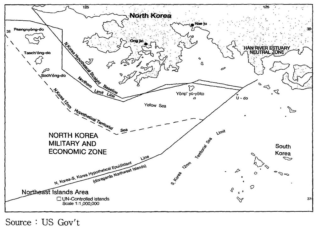
English: A US Government map showing where a North Korean 12 nautical mile Territorial Waters limit would be, when disregarding the north west UN Command islands, compared to the UN Command created Northern Limit Line. |
| Час створення | Невідома дата |
| Джерело | http://118.129.184.33/pub/docu/kr/AM/06/AM062001B01/IMAGE/AM06-2001-B01-0210-01.jpg |
| Автор | US Government |
| Інші версії |
Похідні роботи від цього файлу: Yeonpyeong Island live firing range map.png:  |
Map taken from HTML version of the paper, which included this US Government credited map:
Seong-Geol Hong, Sun-Pyo Kim, Hyung-Ki Lee (2001-06-30). "Fisheries Cooperation and Maritime Delimitation Issues between North Korea and Its Neighboring Countries". Ocean Policy Research 16 (1): 191-216. Korea Maritime Institute. Archived from the original on 2011-07-23. Retrieved on 2010-11-28.
HTML version of paper: http://118.129.184.33/pub/docu/kr/AM/06/AM062001B01/AM06-2001-B01-006.HTM[dead link]
According to a Korean Central News Agency article "Northern Limit Line rejected" of 2 August 2002[1] archive copy at the Wayback Machine "the U.S. government distributed [this map] to the participants in the UN conference on maritime law held in the U.S. in 1980". The map is also published in paper by Kim, Jung-Gun (Spring-Summer 1985). "Reflections on the attitude of North Korea toward the Law of the Sea (UNCLOS III Treaty)". Asian Perspective 9 (1)., and John Barry Kotch & Michael Abbey in Asian Perspective, Vol. 27, No. 2, 2003, pp. 175-204 archive copy at the Wayback Machine.
The CIA report "The West Coast Korean Islands", BGI RP 74-9, January 1974 (Declassified 2000-04-18 as CIA-RDP-84-00825R000300120001-7)[2] describes this, or a very similar, map. However the map itself is redacted from the declassified version of the report.
Ліцензування
Ця робота перебуває в суспільному надбанні в США, оскільки вона є роботою Федерального уряду Сполучених Штатів Америки відповідно до розділу 17, параграфу 1, статті 105 Кодексу США (див. Авторське право).
Увага: Це стосується лише робіт Федерального Уряду США, а не робіт окремих штатів, територій, співдружностей, округів, міст, чи інших територіальних одиниць (див. шаблони-ліцензії штатів). Цей шаблон також не може бути використаний для поштових марок Поштової служби США випущених з 1978 року (див. § 313.6(C)(1) Збірки досвіду з авторського права США). Також це стосується деяких монет США (див. Правила Монетного двору США).
|
 | |
| Цей файл визнано вільним від відомих обмежень з боку закону про авторські права, включаючи всі пов'язані і суміжні права. | ||
Історія файлу
Клацніть на дату/час, щоб переглянути, як тоді виглядав файл.
| Дата/час | Мініатюра | Розмір об'єкта | Користувач | Коментар | |
|---|---|---|---|---|---|
| поточний | 23:05, 28 листопада 2010 | | 1315 × 938 (147 КБ) | Rwendland | {{Information |Description={{en|1=A US Government map showing where a North Korean 12 nautical mile Territorial Waters limit would be, when disregarding the north west UN Command islands, compared to the UN Command created Northern Limit Line.}} |Source=h |
Використання файлу
Така сторінка використовує цей файл:
Глобальне використання файлу
Цей файл використовують такі інші вікі:
- Використання в en.wikipedia.org
- Використання в fr.wikipedia.org
- Використання в id.wikipedia.org
- Використання в ko.wikipedia.org
- Використання в no.wikipedia.org
- Використання в ru.wikipedia.org
- Використання в vi.wikipedia.org
- Використання в zh.wikipedia.org