Шаблон:Військова споруда/документація
Перейти до навігації
Перейти до пошуку
Використання[ред. код]
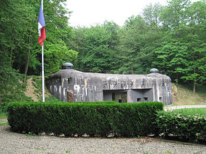
| Лінія Маґіно | |
|---|---|
 Вхід до Овраж Шьоненбурґ з лінією Маґіно. | |
| Тип | Оборонна лінія |
| Розташування | Східна Франція |
| Споруджено | 1930–35 |
| Будівельні матеріали |
Бетон, сталь |
| На службі | 1935–69 |
| Controlled by | Франція |
| Битви/війни | Французька кампанія |
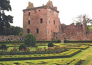
| Едзельський замок | |
|---|---|
 Едзельський замок з садами | |
| Тип | Вежа і внутрішній двір |
| Координати | 56°49′ пн. ш. 2°41′ зх. д. / 56.81° пн. ш. 2.68° зх. д.Координати: 56°49′ пн. ш. 2°41′ зх. д. / 56.81° пн. ш. 2.68° зх. д. |
| Розташування | біля Едзель, Ангус, Шотландія |
| Споруджено | c.1520-1610 |
| Збодовано | Девід Ліндсі, 9ий граф Крофордський |
| Будівельні матеріали |
Древній червоний пісковик |
| На службі | до 1715 |
| Поточний стан |
знищена |
| Поточний власник |
Граф Дальхоський, керує Історична Шотландія |
| Доступний для відвідувачів |
так |
| Controlled by | Ліндсі з Едзеля |
Шаблон Військова споруда може використовуватись для подання інформації про військову споруду, наприклад укріпління чи військову базу.
{{Військова споруда
| name =
| native_name =
| partof =
| location =
| image =
| caption =
| map_type =
| map_relief =
| latitude =
| longitude =
| map_size =
| map_alt =
| map_caption =
| type =
| coordinates =
| coord_region =
| code =
| built =
| builder =
| materials =
| height =
| used =
| demolished =
| condition =
| ownership =
| open_to_public =
| controlledby =
| garrison =
| current_commander =
| commanders =
| occupants =
| battles =
| events =
| image2 =
| caption2 =
}}
Note: When using parameters, avoid the ambiguous abbreviation "N/A", and instead use "unknown" or "none". All subjective or qualitative judgements and numerical quantities or statistics must be cited to a reliable source (see WP:MILMOS#CITE).
- name – назва споруди чи об'єкту.
- native_name – необов'язковий – the name of the structure in the language(s) of the country which built it, or in which it is located.
- partof – необов'язковий – the larger structure or complex the given structure is part of, if any. For proper grammar, it may be necessary to insert "the" before the name used here.
- location – the geographical location of the structure.
- image – необов'язковий – an image of the structure. The image must be given in the form [[Image:Example.jpg|300px]]; in particular, the thumb attribute must not be selected.
- caption – необов'язковий – the text to be placed below the image.
- map_type – необов'язковий – the base map to be used for the location map, e.g. "Scotland"; see {{location map}} for more details.
- map_relief – необов'язковий – set to any non-blank value to use a relief map (if available)
- latitude – необов'язковий – latitude for placing the marker on the location map, e.g. "56.81".
- longitude – необов'язковий – longitude for placing the marker on the location map, e.g. "-2.68".
- map_size – необов'язковий – width of the location map in pixels (px), e.g. "150"; defaults to: "220".
- map_alt – необов'язковий – alt text for location map; see Wikipedia:Alternative text for images.
- map_caption – необов'язковий – caption displayed below the location map; defaults to "Shown within {{{map_type}}}", e.g. "Shown within Scotland".
- type – необов'язковий – the general type of structure ("Castle", "Fortress", "Bunker", "Military base", "Wall", "Defensive line", etc.).
- coordinates – необов'язковий – the location of the structure, given as a coordinate pair by using {{coord}} with display=inline,title.
- coord_region – необов'язковий – the region code for the coordinates; see {{coord}} for more details.
- code – необов'язковий – the location or facility code, such as the ILC or ILK code.
- built – необов'язковий – the date when the structure was built (usually given in years). Use {{Start date}} if after 1583.
- builder – необов'язковий – the person or group responsible for building the structure.
- materials – необов'язковий – the materials used to construct the structure.
- height – необов'язковий – where relevant (e.g. for towers), the height of the structure.
- used – необов'язковий – the period during which the structure was in active military use, usually given in years.
- demolished – необов'язковий – the date when the structure was demolished, if applicable.
- condition – необов'язковий – the current condition of the structure.
- ownership – необов'язковий – the current owner of the structure, if relevant.
- open_to_public – необов'язковий – whether the structure is currently open to the general public, if relevant; indicated by "yes" or "no".
- controlledby – необов'язковий – the country or other power controlling the structure. Multiple powers may be indicated together with the corresponding dates.
- garrison – необов'язковий – the military forces garrisoning the structure. Specific units may be indicated if known; general numbers should be given otherwise.
- current_commander – необов'язковий – for structures currently in military use, the current commanding officer.
- commanders – необов'язковий – any notable individuals that commanded the forces using this structure; the choice of which commanders qualify as notable is left to the editors of a particular article.
- occupants – необов'язковий – any notable occupants of the structure other than its commanders; as above, the choice of which occupants qualify as notable is left to the editors of a particular article.
- battles – необов'язковий – any notable battles (usually sieges) that took place in or are closely associated with the structure; as above, the choice of which battles qualify as notable is left to the article editors.
- events – необов'язковий – any notable non-battle events that took place in or are closely associated with the structure. As above, the choice of which events are notable is left to the article editors.
- image2 – необов'язковий – a second image of the structure. The image must be given in the form [[Image:Example.jpg|300px]]; in particular, the thumb attribute must not be selected.
- caption2 – необов'язковий – the text to be placed below the second image.